Ain Umm al-Dabadib
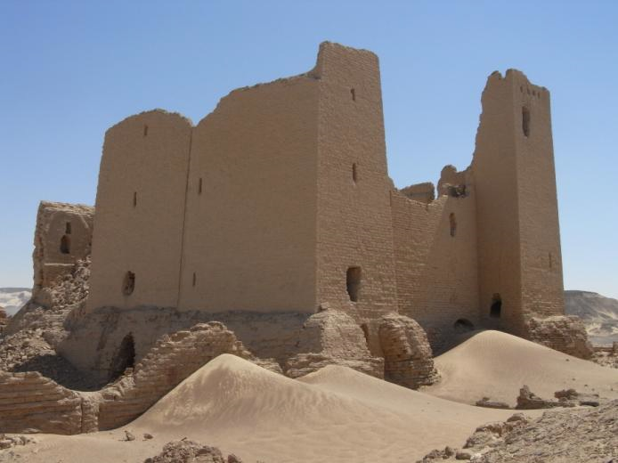
Ain Umm al-Dabadib is an important Roman settlementwhich lay on the Darb Ain Amur, the ancient route to Dakhla Oasis. It is located 18 kilometres (11 miles) west of Qasral-Labekha and 40 kilometres (25 miles) east of Ain Amur, at the base of the north-western escarpment. Dunes dominate the route to Ain Umm al-Dabadib. They form three 30 to 40 kilometre (18 to 25 mile) parallel lines of tall mounds following one another. The use of a 4×4 vehicle with an expert driver and a knowledgeable guide are recommended to reach the location. In the site of Ain Umm al-Dabadib there is evidence of an ancient river and the area is known to be inhabited in Microlithic and Neolithic times. Then the Romans built a major settlement where hundreds, if not thousands, of people lived. The most impressive ruin on the site is an extensive network of qanats (aqueducts) which once provided water for the settlement and the surrounding cultivation. Today the water system is still intact, snaking its way north from the town to the escarpment. On the site there are also the ruins of a mudbrick fortress, located 0.5 kilometres (0.3 miles) southeast of the ruins of the town. Although it is now largely in ruins, its walls once stood to a height of 15 meters. The entrance is in the south and each corner is fortified with a massive rectangular tower. This design sets it aside from the other fortresses in Kharga which all had round towers, and this may suggests that the fortress was build in a later period compared to the other fortresses in the oasis. Originally the fortress contained rooms on three floors, but only the much disturbed remains of the vaulted rooms of the first floor can be seen now. A Coptic chapel was later built on top of the remains of the fortress. A church was located to the east of the fortress but this has been almost completely destroyed by looters. Near it is a temple built in Egyptian style with walls slanting inwards. The area ofAin Umm al-Dabadib is characterized by soft colour, soft sands, and soft light. Along the route to the site there are huge multi-layered whale dunes hundreds of feet high. Further east are the pink, white, and black slopes of two mountains: Gebel el Tarif and Gebel el Sheikh. Gebel el Tarif, or the Mountain of the Border, is the highest and largest mountain within Kharga Oasis (432 meters; 1,384 feet); Gebel elSheikh, the Mountain of the Leader, is a small, circular mountain tucked into the north-western side of Gebel el Tarif (CISS Inventory 2010; Vivian 1990).
Site coordinates: N 25 43 459 E 30 25 180